If you look at any river on the map, you can see that they have a sinuous shape. Why is this happening, because it is more logical to flow along a direct and short path to the place where the river flows?
Education and river types
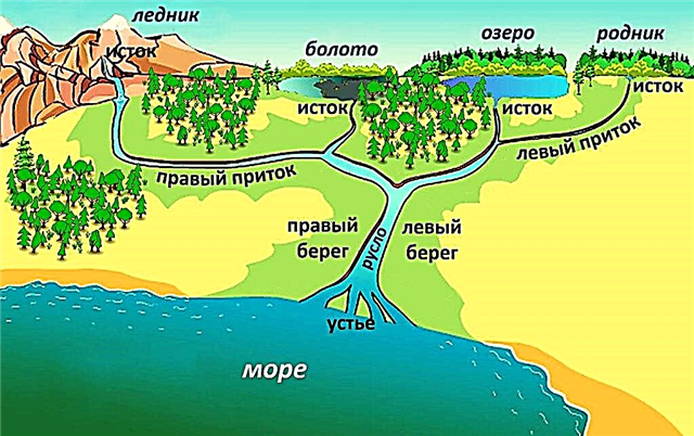
The river begins with small streams, swamps, lakes or mountain glaciers. Large rivers most often begin with large bodies of water, such as the Neva, flowing from Lake Ladoga.
A small stream forms a stream, then - river flows. Some of the streams become rivers, while others are their tributaries. If rains are not uncommon in the area where a large river flows, then it will have many tributaries and a developed river system.

The terrain of the river system is called the pool. In arid areas, even large rivers, there will be very few tributaries. For example, the Nile River in Africa feeds on rains that fall at the equator. For comparison, the area of the stream forming the stream is several square meters.
The creek basin already occupies several hectares, but near the river it expands to kilometers. The line that conditionally divides the catchment is called the watershed.
In winter, rivers are fed by groundwater, and in spring - by melting snow or a glacier. In the summer, rains participate in the catchment.
Interesting fact: some rivers have only one food. For example, the Amazon is filled with rains, and glaciers are involved in the nutrition of the Amu Darya.

There are several river classifications. They are divided by size:
- Large are rivers with a catchment basin of 50,000 km2 or more, as well as most mountain rivers with a pool of 30,000 km2 or more.
- Medium - rivers located on the plain, with basins of 2,000 - 50,000 km2 and located on the same hydrographic territory.
- Small - rivers on the same hydrographic territory with a basin area of up to 2,000 km2. Such a body of water can also be considered a stream.
Also, rivers are divided depending on the area:
- Mountain - rivers with rapid currents, strong slopes, flowing mainly in narrow valleys and with predominant erosion processes.
- Plain - rivers with meanders of the channel. Here the process of erosion and at the same time sediment is observed. As a result of this, deltas are formed in the estuaries, and in the remaining areas ridge and riffles are formed. The branches of a lowland river can flow into another river.

In addition, rivers are classified according to the network of tributaries, food conditions, age, and even water sports opportunities.
How do river meanders appear?
The river will never be straight. It obeys the terrain where it flows. The flow of water will overcome the hills and hills, bypassing them from the side. The river gyrus arises as a small turn in front of an obstacle.
Further, the force of water is used - the pressure on the outside increases and the shore gradually erodes. On the inside, the pressure is lower and the remains of plants, sand, silt settle here, forming bends.

The sinuosity of the river depends on the terrain and the obstacles through which it has to go.Even if an unexpected obstacle has already appeared on the existing path (rockfall, etc.), the river will make itself a new gyrus-path.


